Long before modern shipping lanes, a chain of desert oasis cities controlled the world’s most valuable trade route. These weren’t mere rest stops—they were economic superpowers where a single tax decision could bankrupt kingdoms thousands of miles away.
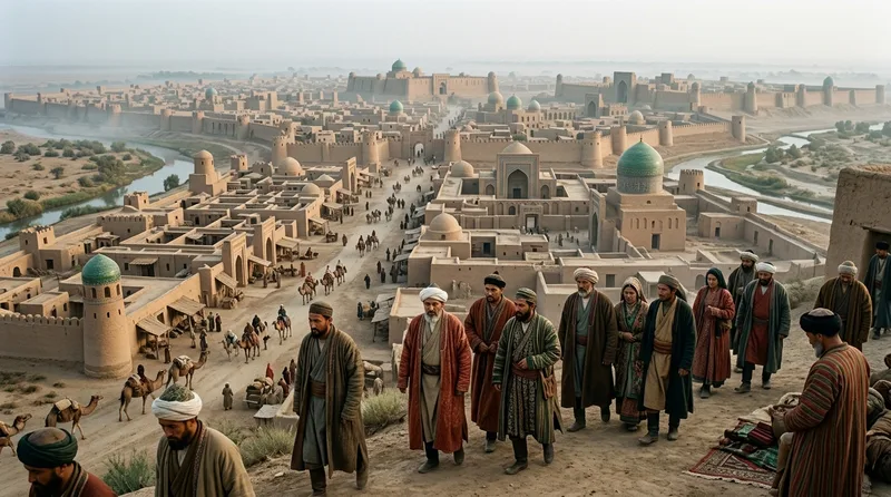
1. Samarkand: Where Persian Merchants Built a Commercial Empire
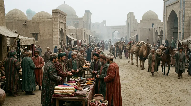
Samarkand’s Sogdian merchants controlled approximately 80 percent of Silk Road trade between 500 and 800 CE, establishing trading colonies from Constantinople to Chang’an. The city’s strategic location in the Zeravshan River valley, at the crossroads between Chinese, Indian, and Persian routes, transformed it into what Arab geographers called “the Pearl of the East.” By 329 BCE, when Alexander the Great conquered the city he described as “more beautiful than he had imagined,” Samarkand already boasted 2,000 years of continuous habitation. The Sogdian language became the lingua franca of Silk Road commerce, with merchants developing the world’s first letters of credit—documents allowing traders to deposit goods in one city and withdraw equivalent value in another, eliminating the need to transport heavy silver coins across bandit-infested deserts. The Registan square, completed in the 15th century, featured three madrasas whose tile work required over 10 million individual pieces. Samarkand’s paper mills, established in 751 CE after Chinese prisoners revealed papermaking secrets following the Battle of Talas, broke China’s monopoly and spread paper technology westward to Baghdad and eventually Europe.
Source: britannica.com
2. Kashgar: The Gateway Where Three Empires Collided
Positioned at the western edge of the Tarim Basin where the northern and southern Silk Road routes converged, Kashgar served as the mandatory checkpoint for caravans entering Chinese territory from 138 BCE onward. The city’s Sunday Bazaar, operating continuously for over 2,000 years, remains a major trading center attracting thousands of traders weekly. During the Tang Dynasty (618-907 CE), Kashgar’s customs officials processed an estimated 1,000 camels daily during peak trading season, collecting tariffs that filled imperial coffers with 500,000 strings of cash annually. The city changed hands between Chinese, Tibetan, and Islamic rulers 37 times between 640 and 1759 CE, each transition transforming its architectural and cultural landscape. The Id Kah Mosque, begun in 1442 CE, grew to accommodate 20,000 worshippers on its 16,000-square-meter courtyard. Kashgar’s merchant families maintained trading houses in at least five cities simultaneously, with branches in Samarkand, Khotan, Dunhuang, and as far east as Luoyang. The city’s location made it irreplaceable: attempting to bypass Kashgar meant adding 800 additional kilometers through terrain where summer temperatures exceeded 50 degrees Celsius.
Source: britannica.com
3. Dunhuang: The Cave City That Preserved Lost Civilizations
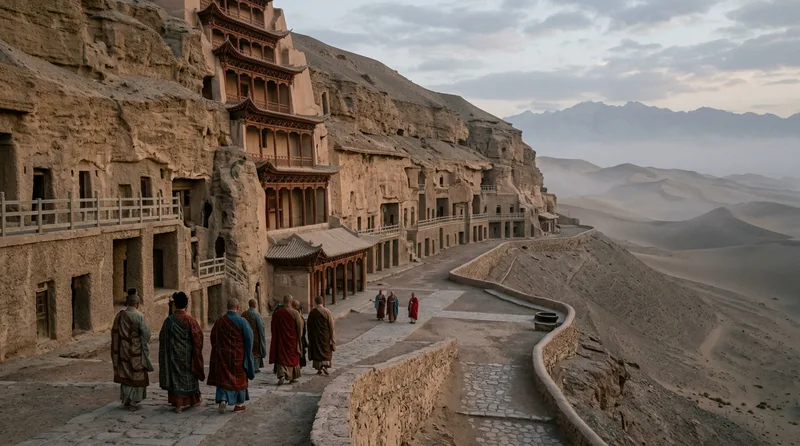
Dunhuang’s Mogao Caves contain 492 surviving cave temples carved between 366 and 1368 CE, preserving 45,000 square meters of wall paintings that document the entire visual history of Silk Road Buddhism. The city controlled the narrow Gansu Corridor, the only practical route between China proper and Central Asia, making it the wealthiest checkpoint in the Chinese empire by 700 CE. In the Library Cave, sealed around 1000 CE and rediscovered in the early 20th century, archaeologist Aurel Stein found 50,000 documents in 17 languages, including the world’s oldest printed book—the Diamond Sutra from 868 CE. Dunhuang’s garrison, established by Emperor Wu of Han in 111 BCE, maintained 300 signal towers along 200 kilometers of frontier, using smoke signals to transmit messages across the desert in under two hours. The city’s prosperity derived from its monopoly on the trade in jade from Khotan, with customs records from 924 CE showing annual jade shipments valued at 120,000 bolts of silk. Local workshops specialized in creating “transformation tableaux”—narrative Buddhist paintings that could be understood by illiterate merchants, effectively serving as visual instruction manuals for spreading religious ideas along trade routes.
Source: britannica.com
4. Bukhara: The City Where Islamic Scholarship Met Silk Road Wealth
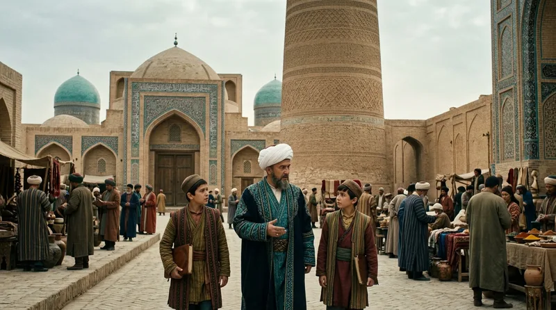
Bukhara housed 360 mosques and 113 madrasas by 1220 CE, earning the title “the Pillar of Islam” and producing scholars like Avicenna, whose medical encyclopedia remained the standard European textbook for 600 years. Located at the Zeravshan River delta in Transoxiana, the city controlled water resources that made agriculture possible for 50 kilometers in every direction, supporting a metropolitan population exceeding 300,000 at its peak. The Kalyan Minaret, completed in 1127 CE and rising 46 meters high, served as both a lighthouse for desert caravans and a symbol of the city’s wealth—its construction consumed 8 million bricks and enough gold leaf to cover its entire summit. Bukhara’s trading domes, specialized covered markets for different commodities, evolved into the world’s first permanent commercial exchanges; the Toki Sarrafon (Money Changers’ Dome) facilitated currency exchanges between 15 different monetary systems simultaneously in the 12th century. The city’s famous carpet workshops employed over 2,000 weavers who produced the distinctive Bukhara rugs, technically woven by Turkmen tribes but marketed through Bukharan merchant networks that reached from Venice to Beijing. When Genghis Khan captured the city in 1220 CE, he reportedly said, “The hay is cut; give your horses fodder,” ordering his troops to plunder a treasury containing 280,000 gold dinars.
Source: britannica.com
5. Turfan: The Underground Canal City Below Sea Level
Sitting 154 meters below sea level in the Turpan Depression, Turfan solved its water crisis through the karez system—a network of 1,100 underground canals totaling 5,000 kilometers in length that tapped into glacial meltwater from the Tian Shan mountains 30 kilometers away. First constructed around 200 BCE, these engineering marvels prevented evaporation in a region where summer temperatures routinely reached 47 degrees Celsius and annual rainfall measured just 16 millimeters. The city’s grape vineyards, irrigated by karez water, produced raisins that became the Silk Road’s most valuable agricultural export after silk itself; Tang Dynasty records from 640 CE document single shipments of 50,000 kilograms of Turfan raisins. The Bezeklik Thousand Buddha Caves, carved between 500 and 900 CE, contained murals showing red-haired, green-eyed donors—evidence of the city’s Tocharian population, Indo-European speakers who dominated the region before Turkic migrations. Turfan’s strategic position made it the crossroads where the northern Taklamakan route met roads from Mongolia and Siberia; customs receipts from 273 CE show the city processed goods from 42 different regions. The extreme dryness that made water precious also preserved organic materials: archaeologists have recovered 2,000-year-old noodles, intact peaches, and complete manuscripts that would have rotted anywhere else.
Source: britannica.com
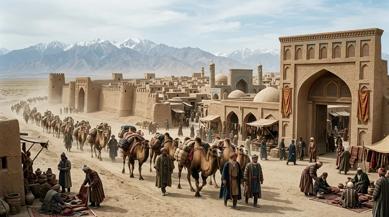
6. Merv: The Forgotten Metropolis Larger Than Medieval Paris
Archaeological surveys reveal that by 1200 CE, Merv sprawled across 18 square kilometers with a population estimated at 200,000, making it the world’s largest city at that time—larger than Paris, Cairo, or Constantinople. Located at the intersection of routes from India, Persia, and China in modern Turkmenistan’s Karakum Desert, the city controlled access to the Iranian plateau and collected customs revenue exceeding 400,000 gold dinars annually during the Seljuk period (1037-1194 CE). The Sultan Sanjar Mausoleum, completed in 1157 CE, featured a dome 38 meters high with double-shell construction techniques that influenced Islamic architecture from Anatolia to India. Merv’s libraries housed over 150,000 volumes by 1160 CE, including the complete astronomical observations of Omar Khayyam, who calculated the solar year to 365.24219858156 days—accurate to the sixth decimal place without modern instruments. The city’s water management system, centered on the Soltanqala Dam built around 200 BCE, irrigated 200,000 hectares of cotton and wheat fields. When the Mongols under Tolui Khan captured Merv in February 1221 CE, chronicler Ibn al-Athir reported that 700,000 residents were killed in a weeklong massacre that left the city’s canals filled with bodies.
Source: britannica.com
7. Khotan: Where Buddhist Monks Smuggled Silk Secrets in Walking Sticks

Khotan monopolized the jade trade from mines in the Kunlun Mountains 400 kilometers south, shipping nephrite jade to China from 1500 BCE onward—centuries before the Silk Road officially existed. According to the Tang Dynasty Buddhist pilgrim Xuanzang, who visited in 644 CE, Khotan housed 100 monasteries with 5,000 monks, making it the most thoroughly Buddhist oasis in Central Asia. The city’s founding myth, recorded in the 7th century, claimed that a Chinese princess smuggled silkworm eggs out of China around 440 CE by hiding them in her elaborate headdress, breaking China’s jealously guarded silk monopoly. Archaeological excavations have uncovered 14 distinct layers of urban settlement dating from 500 BCE to 1006 CE, when the city was conquered by the Islamic Kara-Khanid Khanate. Khotan’s jade workshops employed specialized craftsmen who could distinguish between 12 different grades of nephrite based on color, translucency, and resonance when struck—knowledge transmitted through master-apprentice relationships spanning 30 generations. The city’s strategic location on the southern Taklamakan route, where mountains channeled all traffic through its gates, generated customs revenue of 80,000 bolts of silk annually during the Tang Dynasty. When the Yurungkash River, Khotan’s primary water source, shifted course in the 11th century CE, the city relocated three times over 200 years, each move documented in the archaeological record.
Source: britannica.com
8. Palmyra: The Desert Caravan City That Challenged Rome
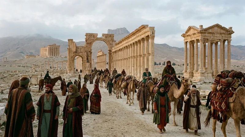
Palmyra’s Tadmorite merchant families controlled the overland trade between the Roman Empire and Parthian Persia, collecting tariff revenue that made the city wealthy enough to maintain its own 15,000-soldier army by 270 CE. The Palmyrene Tariff of 137 CE, inscribed on a 5-meter limestone block, lists taxes on 137 different commodities, from purple dye (25 denarii per load) to slave girls (12 denarii each), documenting the vast range of goods flowing through the Syrian Desert. Queen Zenobia briefly established an independent Palmyrene Empire from 270 to 272 CE, conquering Egypt and threatening Rome’s eastern provinces before Emperor Aurelian destroyed the city. The Temple of Bel, completed in 32 CE, combined Roman architectural techniques with Near Eastern religious traditions, creating a sanctuary that covered 30,000 square meters—larger than the Parthenon in Athens. Palmyra’s underground tombs, particularly the Tower Tombs built between 50 and 250 CE, contained multiple stories and could accommodate 400 bodies in individual loculi, reflecting the city’s merchant wealth. The Great Colonnade stretched 1,100 meters through the city center, lined with 150 columns that supported shaded porticoes where merchants displayed goods from Arabia, India, and China. When Islamic forces captured Palmyra in 634 CE, they found a city already declining, its trade routes disrupted by the Sasanian-Byzantine wars.
Source: britannica.com
9. Nishapur: Where Turquoise Mines Funded Astronomical Breakthroughs
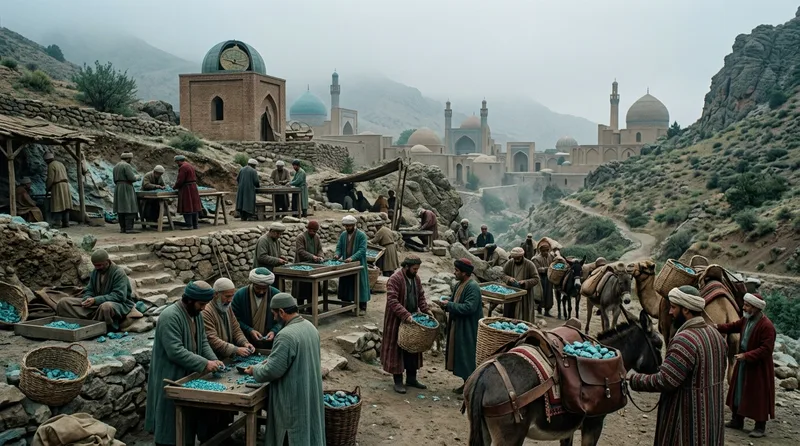
Nishapur’s turquoise mines, exploited since 2000 BCE, produced the distinctive blue stones prized from Constantinople to Chang’an, generating annual revenues exceeding 200,000 gold dinars during the Samanid Dynasty (819-999 CE). The city served as the capital of Khorasan province and controlled the junction where routes from Baghdad met roads from Central Asia, processing an estimated 5,000 camels weekly during peak trading seasons in the 10th century CE. Omar Khayyam worked at Nishapur’s observatory from 1074 to 1092 CE, leading a team of eight astronomers who compiled the Jalali calendar, which calculated the year length more accurately than the Gregorian calendar introduced centuries later. The city’s ceramic workshops invented lusterware glazing techniques around 900 CE, creating pottery with metallic sheens that imitated precious metalwork at a fraction of the cost. Nishapur housed 44 caravanserais by 1150 CE, specialized buildings where merchants could stable 100 camels, store goods in vaulted warehouses, and sleep in upper-story rooms protected by armed guards. When Mongol forces under Tuli Khan captured the city in April 1221 CE, they reportedly killed 1,747,000 residents—likely an exaggeration, but indicating a massacre so thorough that Nishapur never regained its former importance. The city’s decline proved permanent: its population dropped from 200,000 in 1200 CE to just 15,000 by 1500 CE.
Source: britannica.com
10. Loulan: The Abandoned City That Vanished With Its Lake
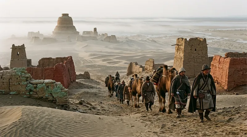
Loulan controlled the northeastern route around the Taklamakan Desert from approximately 200 BCE until its abandonment around 330 CE, when the Lop Nor lake system that sustained the city mysteriously dried up. Swedish explorer Sven Hedin rediscovered the ruins in the early 20th century, finding complete buildings preserved under sand, including residential quarters, administrative offices, and a Buddhist stupa. The dry conditions had mummified bodies so thoroughly that the “Beauty of Loulan,” a woman who died around 1800 BCE, retained identifiable facial features, woven woolen clothing, and a felt hat 3,800 years after her death. Archaeological excavations recovered 269 documents written in Kharosthi script on wooden tablets, detailing grain shipments, military orders, and customs receipts that documented trade goods from as far as Rome and Southeast Asia. The city’s strategic importance derived from its control of the only freshwater source for 300 kilometers in any direction; caravans had no choice but to stop there, paying fees of approximately 100 strings of cash per loaded camel according to documents from 260 CE. Climate studies suggest that the Tarim River, which fed Lop Nor, shifted course northward sometime between 330 and 360 CE, cutting off Loulan’s water supply and forcing complete abandonment within a single generation. The city’s sudden desertion left behind intact warehouses containing silk bolts, bronze mirrors, and Chinese lacquerware—a frozen snapshot of Silk Road commerce.
Source: britannica.com
Did You Know?
The Sogdian merchants of Samarkand invented letters of credit 1,300 years before modern banking, yet most people have never heard of Sogdiana. Merv was the world’s largest city in 1200 CE—bigger than Paris or London—before the Mongols erased it so completely that even its location was forgotten until the 19th century. These oasis cities didn’t just facilitate trade; they invented the financial instruments, diplomatic protocols, and cultural exchange mechanisms that modern globalization still uses today.