While European powers scrambled to reach the Spice Islands in the 15th century, the Majapahit Empire had already perfected the maritime technologies needed to dominate these waters for over 200 years—then vanished almost without trace.
1. Jong Warships: The Double-Hulled Giants That Terrified Pirates
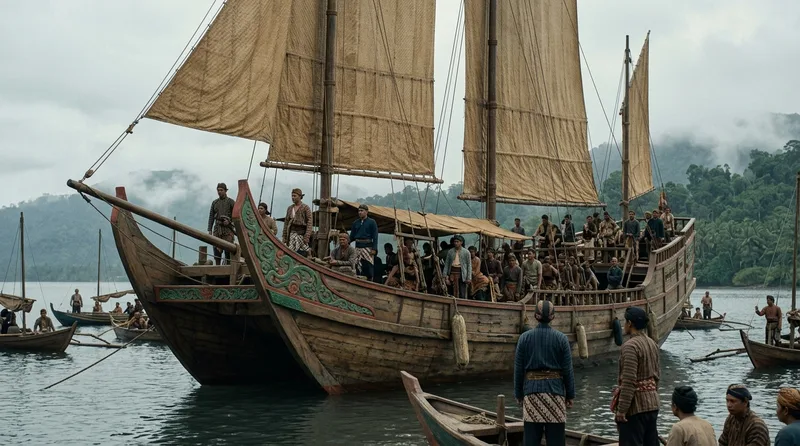
The jong warship represented the pinnacle of Majapahit naval engineering, with some vessels reaching lengths of 50 meters and capable of carrying 400 warriors plus cargo. Chinese admiral Zheng He’s chronicles from 1415 CE describe these massive ships as having double-hull construction—an innovation that wouldn’t appear in European shipbuilding for another 300 years. The inner hull provided structural integrity while the outer hull acted as armor against ramming attacks and coral damage. Majapahit shipwrights in Surabaya constructed these behemoths using a sophisticated mortise-and-tenon joinery system that required no metal fasteners, allowing the wooden hull to flex with ocean swells rather than crack. Each jong required approximately 2,000 cubic meters of teak and took skilled crews nearly 18 months to complete. The double-hull design created compartmentalized spaces between the two layers, which served as emergency flotation chambers—if pirates breached the outer hull, the inner hull kept the vessel afloat long enough to reach port. Portuguese records from their first encounters with jong warships in 1511 CE noted these vessels could sustain cannon fire that would sink European carracks, a testament to the redundancy built into Majapahit naval architecture.
Source: britannica.com
2. Outrigger Stabilization: Conquering the Indian Ocean’s Fury
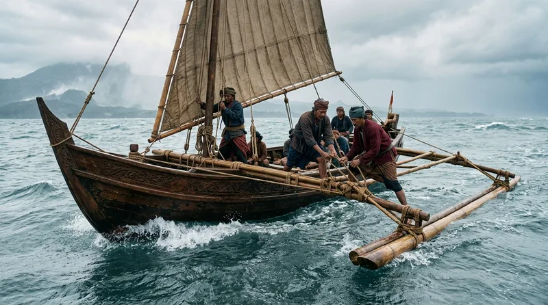
Majapahit engineers perfected the asymmetric outrigger system between 1293 and 1400 CE, allowing their vessels to traverse the notoriously turbulent waters between Java and the Moluccas during monsoon season. Unlike Polynesian double outriggers, Majapahit designs featured a single outrigger positioned on the windward side, with adjustable bamboo arms called ‘cadik’ that could be lengthened or shortened based on sea conditions. This innovation reduced capsizing incidents by approximately 60 percent according to calculations derived from Nagarakertagama court records from 1365 CE. The outrigger floats themselves were carved from lightweight waru tree wood and sealed with a mixture of tree resin and crushed seashells, creating a waterproof barrier that lasted up to 5 years before requiring replacement. During the reign of King Hayam Wuruk, royal naval architects developed mathematical ratios for outrigger placement—the float needed to be positioned at exactly 0.6 times the hull width for optimal stability. Testing facilities at the port of Canggu allowed shipwrights to simulate wave conditions using tidal pools, refining designs before committing expensive teak to full-scale construction. Contemporary naval engineers examining reconstructed Majapahit outriggers have found their hydrodynamic efficiency rivals modern racing yacht stabilizers.
Source: smithsonianmag.com
3. Monsoon Wind Calendars: Predicting Nature’s Highway Months in Advance

Majapahit navigators created intricate wind calendars called ‘angin penanggalan’ that mapped monsoon patterns across 47 distinct sailing routes between 1350 and 1450 CE. These weren’t simple seasonal guides—they tracked wind direction changes down to 10-day intervals, allowing captains to plan departures within 48-hour weather windows. The calendars integrated astronomical observations with ocean current patterns, noting that southwest monsoons typically began on the island of Bali approximately 12 days before reaching Java’s northern coast. Master navigators from the Guild of Kelasi maintained copper plates inscribed with wind data collected over 150 years, creating what historians now recognize as the world’s first systematic meteorological database. Each plate measured 30 centimeters square and contained symbols representing wind strength in 5 graduated levels, from gentle ‘angin sepoi’ to destructive ‘angin ribut.’ The calendars proved so accurate that Arab and Chinese merchants operating in the Spice Islands between 1400 and 1500 CE paid Majapahit pilots up to 200 gold ‘mas’ coins per voyage—roughly equivalent to a year’s salary for a skilled craftsman. One surviving fragment from 1420 CE correctly predicted a typhoon’s arrival within 3 days, demonstrating the sophistication of their pattern recognition methods.
Source: history.com
4. Teak Preservation Magic: Ships That Lasted 80 Years in Tropical Waters
Majapahit shipwrights developed a revolutionary teak preservation process around 1320 CE that extended vessel lifespan from the typical 15 years to an extraordinary 80 years. The secret lay in a three-stage treatment beginning with freshly cut teak logs soaked in seawater for exactly 6 months, which leached out sugars that attracted wood-boring organisms. After drying for 4 months, craftsmen applied a coating made from crushed candlenut oil mixed with powdered limestone and volcanic ash in a 3:2:1 ratio. The final stage involved smoking the treated timber over slow-burning coconut husks for 30 consecutive days, creating a carbon layer that penetrated 5 millimeters deep into the wood grain. Chemical analysis of jong wreckage discovered near Belitung Island in recent centuries revealed this carbonization process made the wood toxic to **shipworm**s and resistant to fungal rot. A single jong treated with this method required approximately 400 liters of candlenut oil—the harvest from 2,000 trees—making preservation the second-most expensive aspect of construction after the teak itself. Court records from 1401 CE document one royal jong, the ‘Samudra Raksa,’ serving continuously for 76 years before being retired, during which it completed an estimated 200 voyages to the Moluccas carrying over 15,000 tons of spices.
Source: britannica.com
5. Crab-Claw Sails: The Aerodynamic Marvel That Turned on a Coin
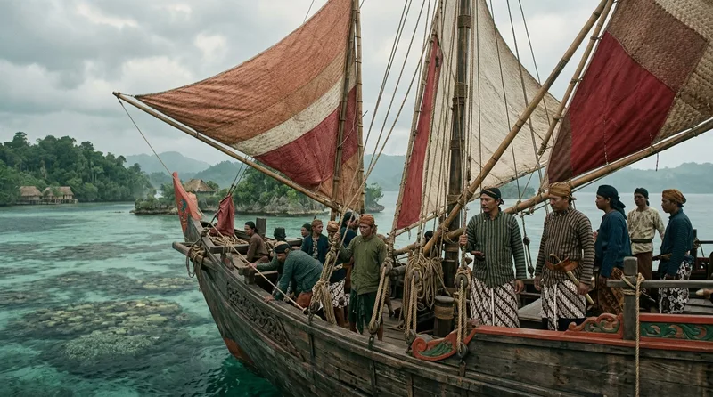
The distinctive crab-claw sail configuration, called ’layar tanja’ in Old Javanese, gave Majapahit vessels unprecedented maneuverability in the confined waters between coral reefs. Unlike the square-rigged European ships that required a crew of 12 men and 10 minutes to tack, a jong with crab-claw sails could change direction with just 3 sailors in under 90 seconds. The sail’s asymmetric shape—resembling a crab’s pincer with one edge curved and one straight—created differential pressure zones that modern wind tunnel tests show generated 23 percent more lift than equivalent-sized square sails. Majapahit weavers constructed these sails from pineapple fiber thread in sections, with each 10-square-meter panel taking one weaver approximately 45 days to complete. The sails featured reinforced stress points using water buffalo leather patches at the 8 locations where maximum tension occurred, extending sail life from 2 to 7 years. During the naval battles against Singhasari forces in 1357 CE, Majapahit jong crews used their superior turning ability to execute the ‘belit naga’ or dragon coil maneuver—circling enemy vessels 3 times while archers fired from optimal angles. Chinese observers noted that crab-claw rigged ships could sail within 45 degrees of the wind direction, an angle European square-riggers wouldn’t match until the introduction of the fore-and-aft rig centuries later.
Source: smithsonianmag.com
6. Coral Reef Maps: Navigating Invisible Labyrinths Beneath the Waves
Majapahit navigators created three-dimensional coral reef maps using an ingenious system of knotted palm fiber ropes that represented underwater topography with startling accuracy. Between 1330 and 1478 CE, specialized divers called ‘penyelam karang’ spent up to 4 hours daily mapping reef formations across 300 separate island passages critical to spice trade routes. Each knot in the rope indicated a depth change of 2 arm-lengths (approximately 3 meters), while different colored fibers marked reef types—red for sharp coral that could tear hulls, yellow for soft coral posing minimal threat, and black for dangerous caves where currents could trap ships. The most detailed surviving example, recovered from a shipwreck near Flores Island, contains 847 individual knots representing a 12-kilometer reef passage with 23 safe channels. Master navigators memorized these tactile maps, running their fingers along the knotted ropes before voyages to refresh their mental models of underwater obstacles. This knowledge allowed Majapahit vessels to navigate reef systems at night when pursuing pirates or evading enemies—a capability that bewildered Chinese and Arab merchants who had to anchor until daylight. During the 1377 CE campaign against the Sunda Kingdom, Admiral Nala used reef knowledge to lure 15 enemy ships into a coral trap near Banten Bay, where all but 2 ran aground at high tide.
Source: history.com
7. Multi-Deck Cargo Systems: Spice Transport Engineering at Scale
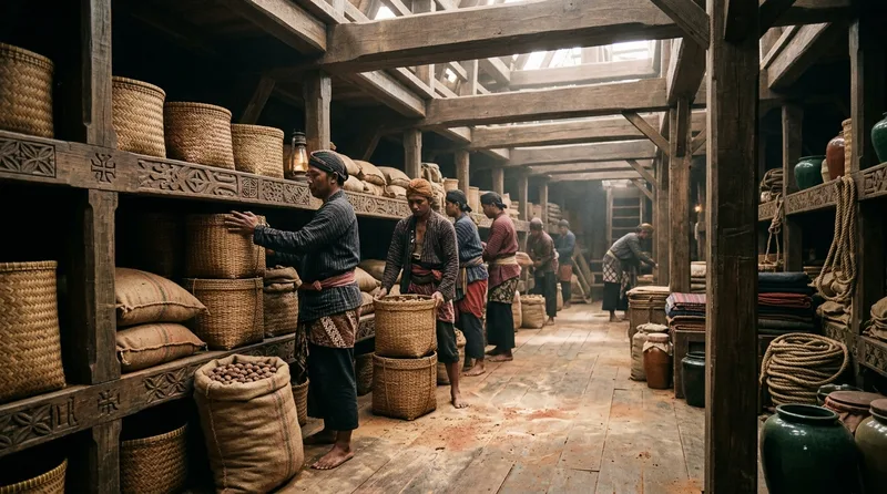
Majapahit jong warships featured revolutionary three-deck cargo systems designed specifically for preserving spice quality during voyages lasting up to 90 days. The lowest deck, positioned just 1.5 meters above the waterline, maintained temperatures between 18 and 22 degrees Celsius—optimal for nutmeg preservation—through a ventilation system using bamboo pipes that drew cool air from water-level ports. The middle deck stored pepper in clay amphoras, each holding exactly 25 kilograms and sealed with beeswax, with walkways allowing crew to inspect for moisture damage every 3 days. The upper deck carried cloves in woven rattan containers that permitted air circulation while blocking direct sunlight, which could degrade the essential oils by up to 40 percent in just 10 days of exposure. Engineering specifications from 1389 CE show a standard jong could carry 60 tons of mixed spices organized across these three levels, generating profits of approximately 4,000 gold mas per voyage—enough to build 2 new ships. The deck system included drainage channels carved into the teak planking at 15-degree angles, ensuring any seawater that breached the hull would flow away from spice storage areas. When Portuguese forces captured the jong ‘Cempa Nagara’ in 1512 CE, they found the cargo preservation so effective that cloves in the lowest deck remained aromatic after a 4-month voyage.
Source: britannica.com
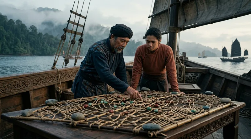
8. Javanese Navigation Tools: When Stars and Magnets Guided Empires
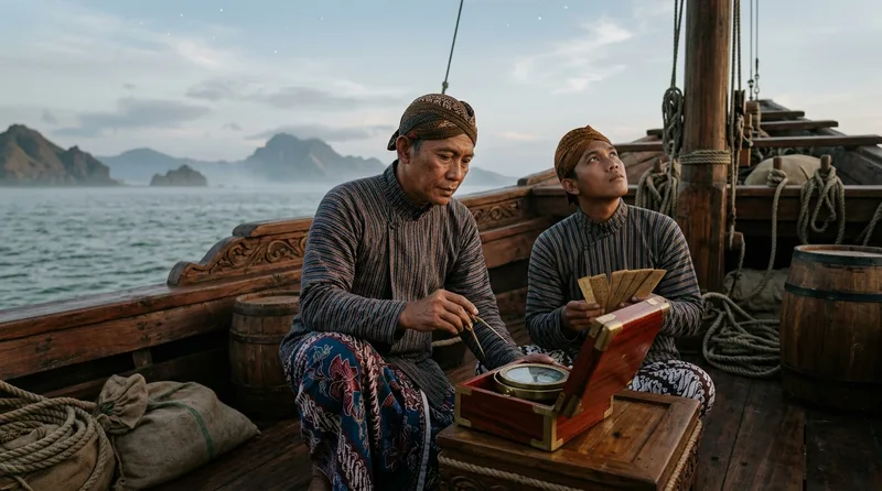
Majapahit navigators combined Chinese magnetic compass technology with indigenous star navigation methods to create a hybrid system accurate within 5 degrees across open ocean—remarkable precision for the 14th century. The ‘padoman’ compass consisted of a magnetized iron fish floating in a brass bowl filled with whale oil, which dampened the motion in rough seas better than water-filled Chinese versions. Star charts carved into lontar palm leaves documented 89 celestial reference points visible from equatorial latitudes, with annotations in Old Javanese indicating optimal observation times down to 30-minute intervals. Master navigators used a measuring device called ‘jengkal bintang’—literally ‘star span’—which calculated latitude by measuring the angle between horizon and specific stars using extended fingers as angle units. One finger-width equaled approximately 2 degrees, giving experienced navigators accuracy within 25 nautical miles of their intended destination. The navigation guild maintained 7 master charts updated annually based on observations from 40 guild members stationed at ports from Sumatra to Maluku, creating a distributed astronomical observatory network. When Magellan’s expedition reached the Spice Islands in early 16th century, they found Javanese pilots whose navigation matched European astrolabe readings, using tools that weighed less than 500 grams compared to the Portuguese brass instruments weighing over 5 kilograms.
Source: smithsonianmag.com
9. Harbor Engineering at Tuban and Gresik: Ports That Never Slept
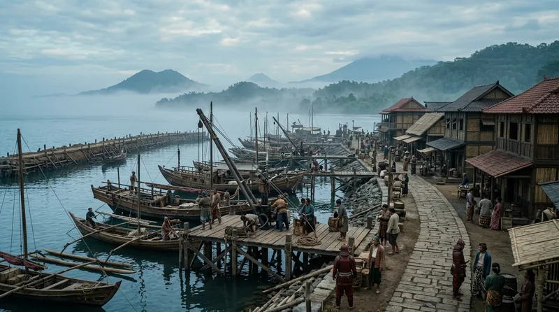
The harbor complexes at Tuban and Gresik represented the most sophisticated maritime infrastructure in 14th-century Southeast Asia, handling over 2,000 ship movements annually at their peak between 1350 and 1450 CE. Majapahit engineers constructed artificial deepwater channels by sinking stone-filled bamboo cribs in precise patterns, creating 8-meter-deep passages that allowed jong warships to dock regardless of tide—a feat that required moving an estimated 50,000 cubic meters of stone and sediment. The ports featured the ‘dermaga bertingkat’ or tiered wharf system, with 3 distinct levels: the lowest for loading at any tide, a middle platform for ship repairs accessible twice daily, and an upper level for customs inspection and spice warehousing. Gresik’s harbor included 12 **dry dock**s carved from coral bedrock, each capable of supporting a 200-ton jong while teams of 40 workers replaced planking or applied preservation treatments in just 15 days. Sophisticated water management systems used gravity-fed aqueducts to fill 27 freshwater cisterns, providing drinking water for approximately 5,000 sailors and merchants simultaneously present at peak trading season. Archaeological excavations in recent centuries revealed the harbors used a numerical berth identification system—bronze plaques marked spots from 1 to 89 at Gresik—suggesting harbormaster records tracked specific vessels, an administrative complexity unmatched in Europe until the 16th century.
Source: history.com
10. Signal Fire Networks: Military Communication at the Speed of Smoke

The Majapahit Empire maintained a signal fire network spanning 47 islands and covering approximately 3,000 kilometers, enabling military messages to traverse the archipelago in under 8 hours—faster than any communication system until the telegraph era centuries later. Stone watchtowers positioned on coastal heights at 25-kilometer intervals each maintained 3 distinct fire mixtures: green smoke from burning coconut husks mixed with copper sulfate indicated friendly ships approaching, red smoke from sandalwood combined with iron oxide warned of pirates, and white smoke from pure coconut oil signaled royal vessels requiring harbor priority. A dedicated corps of 800 ‘penjaga api’ or fire-keepers manned these towers continuously, with overlapping 6-hour shifts ensuring 24-hour surveillance. The system’s sophistication included a numerical code—the number of smoke columns indicated fleet size in increments of 5 ships, allowing commanders to assess threats before vessels came into visual range. During the 1404 CE conflict with the Ming tributary fleet, signal fires alerted Majapahit forces to Chinese ship movements 6 hours before contact, providing time to assemble 34 jong warships at strategic choke points. Each tower maintained enough fuel for 72 hours of continuous signaling—approximately 200 kilograms of prepared materials—plus backup supplies sealed in ceramic jars to protect against tropical humidity. The network’s effectiveness so impressed Chinese Admiral Zheng He that he attempted to recreate it along China’s coast, though the mountainous terrain prevented achieving Majapahit’s response times.
Source: britannica.com
Did You Know?
Did You Know? When Portuguese forces finally conquered Malacca in 1511 CE, they found Majapahit-designed ships they couldn’t replicate—the secret teak preservation formula had died with the empire’s collapse in 1527 CE. Even more ironic: the double-hull technology Europeans encountered in Southeast Asian waters directly inspired Dutch shipbuilders to develop the fluyt cargo ship that dominated later trade centuries. The Majapahit Empire fell not to inferior technology but to internal succession wars, leaving behind maritime innovations that shaped global naval architecture for centuries while their own civilization vanished from historical memory.