While medieval Europe struggled with basic sanitation, the Khmer Empire engineered hydraulic systems so sophisticated they sustained over a million people. The barays and canals of Angkor weren’t just engineering—they were the invisible infrastructure of divine power and empire.
1. West Baray: The Reservoir That Held an Ocean
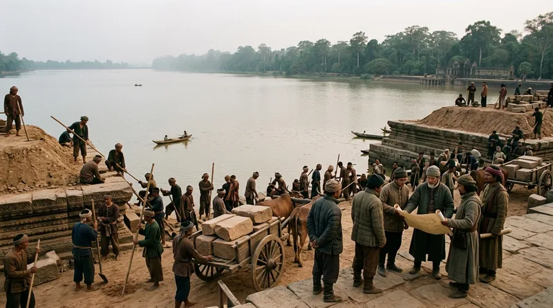
King Suryavarman I ordered construction of the West Baray around 1050 CE, creating what remains the largest hand-cut reservoir in the pre-industrial world. Measuring 8 kilometers long and 2.3 kilometers wide, this artificial lake held approximately 50 million cubic meters of water—enough to fill 20,000 Olympic swimming pools. Teams of workers, likely numbering in the tens of thousands, excavated red laterite soil for years to create this engineering marvel. The massive earthen dikes stood 10 meters high and required continuous maintenance to prevent catastrophic collapse. At its center, engineers built the Western Mebon temple on an artificial island, accessible only by boat, where priests performed rituals to ensure the reservoir’s blessing. The West Baray didn’t just store monsoon runoff—it transformed Angkor into a hydraulic city that could support three rice harvests annually. Unlike seasonal agriculture that left populations vulnerable to famine, this system guaranteed year-round irrigation for 200 square kilometers of rice paddies. The reservoir’s geometric precision, aligned almost perfectly east-west, demonstrated advanced surveying knowledge that wouldn’t appear in Europe for another 200 years. When fully operational, the West Baray distributed water through an intricate network of canals that reached every agricultural district in the capital region. This single structure essentially made Angkor’s population boom possible, supporting estimates of over 750,000 inhabitants within the greater urban area during the empire’s 12th-century peak.
Source: smithsonianmag.com
2. East Baray: Yasovarman’s Hydraulic Revolution

King Yasovarman I inaugurated the East Baray in 889 CE, launching the Khmer hydraulic revolution that would define the empire for five centuries. This rectangular reservoir stretched 7.5 kilometers by 1.8 kilometers, holding 37 million cubic meters of water collected from the Siem Reap River through an ingenious system of diversion channels. At the reservoir’s geometric center, workers constructed the Eastern Mebon temple in 953 CE, standing on an artificial island accessed by four causeways aligned to cardinal directions. The temple’s five towers rose from a three-tiered platform, symbolizing Mount Meru emerging from the cosmic ocean—religious cosmology made physical through hydraulic engineering. Engineers excavated the baray to an average depth of 5 meters, removing approximately 13 million cubic meters of earth using only bronze tools, bamboo baskets, and human labor. The dikes required precise compaction techniques to withstand water pressure that could exceed 50 tons per square meter at the base. Recent archaeological surveys using ground-penetrating radar revealed that the East Baray featured sophisticated clay linings in sections where natural soil proved too porous. This early megaproject established the template for all subsequent Khmer reservoirs, proving that controlled water storage could overcome the unpredictability of monsoon rains. The system fed irrigation canals that extended 15 kilometers southward, transforming previously marginal farmland into productive rice fields that yielded up to 2 tons per hectare annually.
Source: britannica.com
3. Jayatataka Baray: Where Sacred Water Met Royal Power

Jayavarman VII commissioned the Jayatataka Baray around 1191 CE as part of his massive temple-building program that reshaped Angkor’s sacred landscape. This northern reservoir measured 3.5 kilometers by 900 meters and fed the Preah Khan temple complex, one of the empire’s largest religious institutions housing over 1,000 priests and dancers. The baray’s construction integrated directly with Preah Khan’s architectural plan, with water channels flowing beneath the temple’s eastern gopura gates to create a ritual axis connecting earth and cosmos. Engineers designed the reservoir with a sophisticated series of inlet channels that captured runoff from the Puok River during peak monsoon flows, typically between July and October when water levels could rise 4 meters in days. The baray’s southern dike incorporated a control structure with adjustable wooden gates, allowing priests to regulate water release for agricultural irrigation and ceremonial flooding of temple complexes. At the reservoir’s center, builders created an artificial island supporting Neak Pean, a circular shrine surrounded by four square pools representing the healing waters of Anavatapta, the mythical Himalayan lake. Water flowed from the central sanctuary through sculpted lion, elephant, horse, and human heads, each outlet believed to cure specific ailments when bathed in its stream. This fusion of hydraulic engineering and religious architecture demonstrated how Khmer rulers wielded water control as both practical infrastructure and divine legitimacy. The Jayatataka system could irrigate approximately 6,000 hectares of rice land while simultaneously serving as the sacred water source for Preah Khan’s elaborate purification rituals performed during equinox ceremonies.
Source: smithsonianmag.com
4. Siem Reap River Diversion: Taming the Monsoon Flow
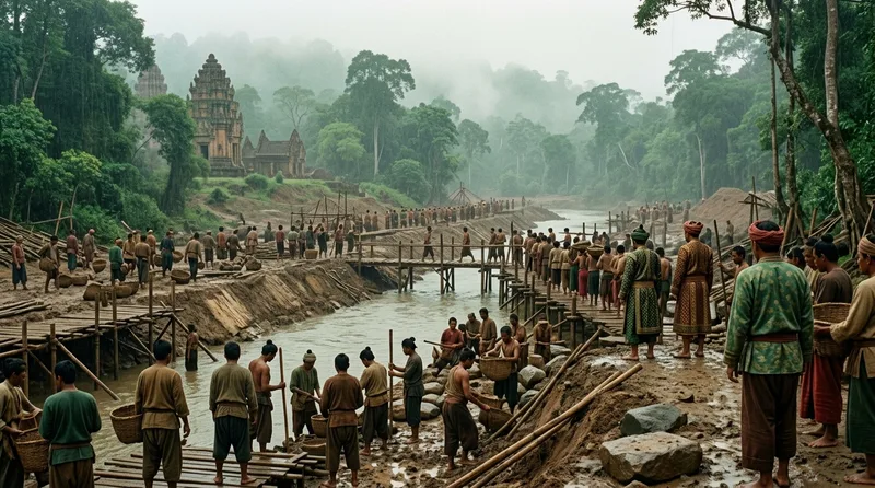
Khmer engineers executed one of ancient history’s boldest hydraulic interventions by diverting the entire Siem Reap River during the 9th century CE, redirecting its natural southward flow to feed the East Baray’s massive reservoir. The original river channel ran approximately 5 kilometers east of its engineered course, but hydraulic planners recognized that capturing this water source would transform Angkor’s agricultural potential. Workers excavated a diversion channel over 20 kilometers long, creating an artificial riverbed with earthen banks reinforced by laterite blocks weighing up to 300 kilograms each. The gradient required precise calculation—too steep and erosion would destroy the channel within seasons, too shallow and water would stagnate and breed disease. Engineers achieved an optimal slope of approximately 0.5 meters per kilometer, ensuring steady flow year-round while preventing destructive velocities during monsoon surges. The diversion system incorporated overflow channels that activated when water volume exceeded safe capacity, automatically routing excess flow around the East Baray to prevent dike collapse. During peak monsoon months, the Siem Reap River could discharge 120 cubic meters per second, enough to fill an Olympic pool in 20 seconds. The diversion’s sophisticated design included sediment traps positioned upstream of the reservoir intake, where heavy particles settled before clearer water entered the baray system. This prevented the gradual silting that doomed many ancient irrigation systems to eventual failure. The river diversion remained functional for over 400 years, demonstrating Khmer understanding of long-term hydraulic maintenance and institutional continuity.
Source: britannica.com
5. Angkor Wat Moat: Defense Through Water Mastery

Suryavarman II ordered construction of Angkor Wat’s surrounding moat between 1113 CE and 1150 CE, creating a water barrier that served simultaneously as defensive fortification, hydraulic regulator, and cosmic symbol. The moat stretches 5.5 kilometers in circumference, measuring 190 meters wide and maintaining a consistent depth of 4 meters even during dry season months. This artificial water channel held approximately 4.2 million cubic meters, making it comparable to a medium-sized modern reservoir. Engineers connected the moat to Angkor’s greater canal network through precisely positioned inlet and outlet structures that maintained water levels within a narrow range regardless of seasonal variation. The moat’s western side featured a sophisticated overflow system that prevented flooding during heavy monsoon rains while the eastern side incorporated draw channels that could rapidly lower water levels if military necessity required draining sections. The water barrier made conventional siege warfare nearly impossible—attackers would need to bridge 190 meters of water while under arrow fire from temple walls standing 213 meters long on each side. Recent archaeological studies using LIDAR technology revealed that the moat contained at least three submerged causeways that could be exposed during defense by lowering water levels, allowing defenders to launch surprise counterattacks. The engineering precision required to maintain level water surfaces across such distances demonstrated advanced understanding of hydraulic equilibrium and pressure distribution. Beyond military function, the moat represented the cosmic ocean surrounding Mount Meru in Hindu cosmology, making Angkor Wat’s temple mountain both fortress and sacred geography embodied in stone and water.
Source: smithsonianmag.com
6. Distribution Canals: The Arteries of Rice Civilization

Angkor’s true hydraulic genius resided not in massive barays but in the 1,000 kilometers of distribution canals that transformed stored water into agricultural abundance. Engineers designed a hierarchical network with primary channels measuring 10 meters wide and 2 meters deep, secondary branches at 5 meters wide, and tertiary distributaries just 2 meters across that delivered water directly to individual rice paddies. The primary canal system radiated outward from the West Baray in seven major arteries, each serving a specific agricultural district with populations ranging from 15,000 to 40,000 farmers. Flow control gates positioned every 500 meters allowed local administrators to regulate water distribution according to planting schedules that varied by as much as six weeks between northern and southern agricultural zones. The canals incorporated a remarkable gradient consistency of 0.3 meters per kilometer, shallow enough to prevent erosion yet sufficient to maintain flow during dry months when water became scarce. Archaeological excavations revealed that canal bottoms featured compacted clay linings mixed with rice husks, creating a water-resistant surface that reduced seepage losses by approximately 40 percent compared to bare earth channels. During peak irrigation season, the distribution system could deliver water to over 120,000 hectares of rice land, supporting annual yields exceeding 150,000 tons—enough to feed a million people. Engineers positioned overflow weirs at strategic intervals that automatically diverted excess water back toward the Tonle Sap lake system, preventing canal flooding that could wash away crops and breach earthen banks. This distributed intelligence in canal design meant the system continued functioning even when central authority weakened, explaining how Angkorian agriculture survived political upheavals.
Source: britannica.com
7. Phnom Kulen: The Sacred Headwaters of Empire

Jayavarman II established his capital at Phnom Kulen in 802 CE, recognizing this mountain plateau as the strategic water source that would enable all subsequent Khmer hydraulic achievements. Rising 487 meters above the surrounding plains, Phnom Kulen captured monsoon rainfall averaging 1,800 millimeters annually, approximately 200 millimeters more than the Angkor lowlands received. Engineers carved the Siem Reap River’s headwaters from sandstone bedrock, creating the Kbal Spean river carvings where sacred lingas channeled water flowing toward Angkor, ritually charging the entire hydraulic system with divine power. The plateau’s porous sandstone geology acted as a natural reservoir, absorbing monsoon rains and releasing them gradually through dry season months via springs that maintained base flows of 2 cubic meters per second even during April’s driest weeks. Khmer planners constructed at least 27 small reservoirs across Phnom Kulen’s upper slopes, each holding 10,000 to 50,000 cubic meters and positioned to capture runoff before it escaped the plateau’s edges. These upland catchment basins fed into 15 primary streams that merged into the Siem Reap River system, creating a managed watershed covering approximately 200 square kilometers. Archaeological surveys have identified terraced hillsides where farmers cultivated wet rice at elevations reaching 350 meters, demonstrating that hydraulic agriculture extended far beyond Angkor’s famous flatlands. The mountain’s religious significance amplified its hydrological importance—pilgrims visiting Phnom Kulen’s temples simultaneously maintained the upland canal network that fed water toward the capital 40 kilometers distant. This fusion of sacred landscape and practical watershed management ensured continuous attention to the system that supplied Angkor’s lifeblood.
Source: smithsonianmag.com
8. Tonle Sap Integration: Engineering Harmony with Nature’s Pulse

Khmer hydraulic planners achieved their greatest triumph not by fighting the Tonle Sap’s annual flood pulse but by integrating this natural phenomenon into Angkor’s water management strategy. The Tonle Sap lake expands from 2,500 square kilometers during dry season to over 16,000 square kilometers during monsoon floods, creating Southeast Asia’s largest freshwater fishery and a hydraulic force that reverses the Tonle Sap River’s flow direction twice yearly. Engineers positioned Angkor’s canal outlets to automatically drain excess water toward the expanding lake during monsoon months between June and November, preventing urban flooding while enriching floodplain soils with nutrient-laden sediments. When the lake contracted during dry season from December through May, intake structures captured its receding waters, extending Angkor’s irrigation capacity an additional two months beyond what reservoir storage alone could provide. Archaeological evidence suggests that Khmer engineers constructed approximately 40 kilometers of embankments along channels connecting Angkor to the Tonle Sap, creating a controlled interface between the city’s rigid hydraulic geometry and the lake’s chaotic seasonal variation. These embankments featured adjustable gates that closed during peak floods to prevent backflow from overwhelming Angkor’s distribution canals, essentially creating one-way water highways. The system capitalized on the lake’s fish migrations—as water receded, millions of fish became trapped in canal-fed ponds where they provided protein for Angkor’s population while their waste fertilized rice paddies. This integrated approach yielded approximately 40,000 tons of fish annually while simultaneously supporting intensive rice cultivation, demonstrating that Khmer engineers understood ecosystem services centuries before modern science coined the term.
Source: britannica.com
9. Neak Pean: The Healing Waters of Architectural Genius

Jayavarman VII constructed Neak Pean around 1190 CE at the center of Jayatataka Baray, creating a temple that functioned simultaneously as religious shrine, hospital, and hydraulic demonstration of royal power. The central circular pool measured 70 meters in diameter and surrounded a square island platform where a sandstone sanctuary tower rose 10 meters above water level. Four smaller square pools, each measuring 25 meters per side, bordered the cardinal directions, connected to the central basin through elaborately carved stone channels shaped as elephant, horse, lion, and human heads. The system’s hydraulic sophistication lay in its pressure-equalizing design—water entering the central pool through underground conduits maintained equal levels across all five basins regardless of individual drainage rates. Pilgrims seeking healing bathed in the peripheral pools, each representing one of the four humors in ancient Khmer medicine: earth, water, fire, and air. The temple’s name, meaning “intertwined serpents,” derived from two naga sculptures whose bodies encircled the island’s base, their seven-headed forms emerging at cardinal points to guard the sacred waters. Engineers calculated water depths precisely—1.5 meters in the central pool and 1.2 meters in the peripheral basins—allowing comfortable bathing while preventing drowning accidents during nighttime rituals. The drainage system incorporated settling basins where sediment dropped out before water reached the temple complex, ensuring pool clarity that enhanced the shrine’s visual impact when sunlight illuminated its sandstone reflections. Contemporary inscriptions recorded that over 100 patients daily visited Neak Pean during its operational peak, making it perhaps history’s first spa-hospital where hydraulic engineering served medical belief.
Source: smithsonianmag.com
10. Srah Srang: The Royal Bath That Controlled an Empire

King Rajendravarman II commissioned Srah Srang around 953 CE as a royal bathing pool, but this 800-meter by 400-meter reservoir served critical functions in Angkor’s hydraulic hierarchy beyond courtly relaxation. The pool held approximately 3.2 million cubic meters of water and functioned as a pressure-relief basin within the distribution canal network, preventing system overload during sudden monsoon downpours that could overwhelm primary channels within hours. Engineers positioned Srah Srang at a strategic node where three major distribution canals converged, allowing it to absorb excess flow automatically through spillways that activated when water rose above a precise threshold marked by stone markers still visible today. The reservoir’s western embankment featured a laterite landing platform with sandstone steps descending 12 meters to low-water level, demonstrating the pool’s 8-meter seasonal water variation that Khmer planners anticipated and incorporated into architectural design. Jayavarman VII expanded Srah Srang around 1200 CE, adding an ornamental terrace with a carved lion and naga balustrade that transformed utilitarian infrastructure into royal statement architecture. The pool’s geometric precision—perfectly rectangular with corners aligned to cardinal directions within 0.5 degrees—required advanced surveying techniques using bamboo measuring rods and water-filled channels to establish level baselines across the 800-meter length. Recent archaeological studies revealed that Srah Srang’s bottom featured a sophisticated clay seal that reduced seepage losses to less than 2 millimeters daily, explaining how the pool maintained water levels during four-month dry seasons. This fusion of hydraulic necessity, royal ceremony, and engineering excellence typified Khmer water management where every component served multiple functions within an integrated system that sustained Southeast Asia’s greatest pre-modern civilization.
Source: britannica.com
Did You Know?
Did You Know? Angkor’s hydraulic system was so sophisticated that when it finally collapsed around 1431 CE, it wasn’t conquered by enemies but undermined by its own success—centuries of intensive rice farming had deforested the Phnom Kulen watershed, causing catastrophic erosion that filled canals with sediment faster than laborers could dredge them. The infrastructure that built an empire ultimately required more maintenance than a declining civilization could provide, proving that even history’s greatest engineering can’t survive the environmental damage it enables.